FIVE DAY FORECAST FOR FREDERICK COUNTY, MD

MDC021.
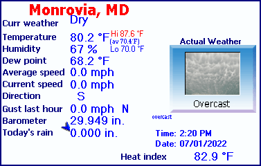
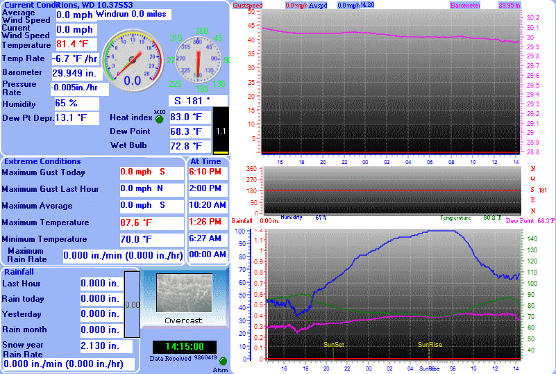
| Monrovia, MD Weather Data |
|---|
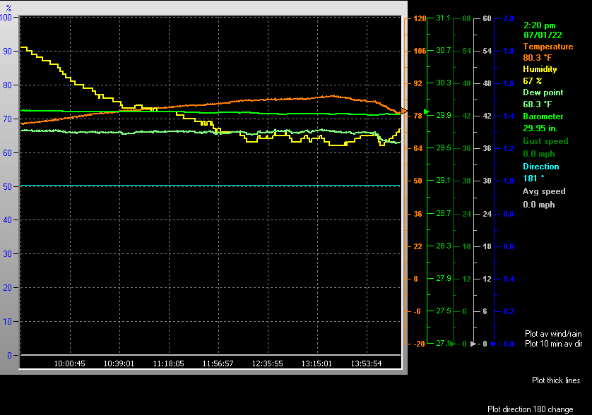
| LAST READING AT TIME: 2:20 PM DATE: July 01 2022, time of next update: 2:30 pm |
|---|
| Current Weather | Dry |
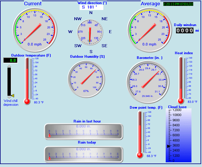
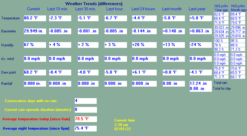
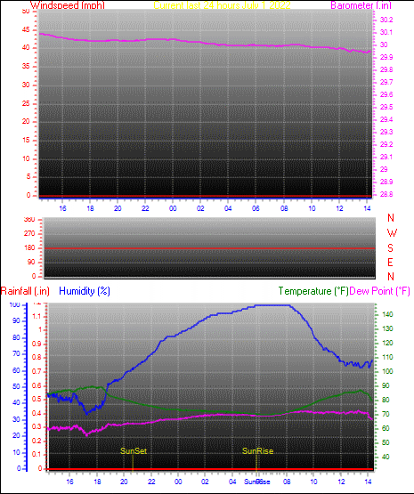
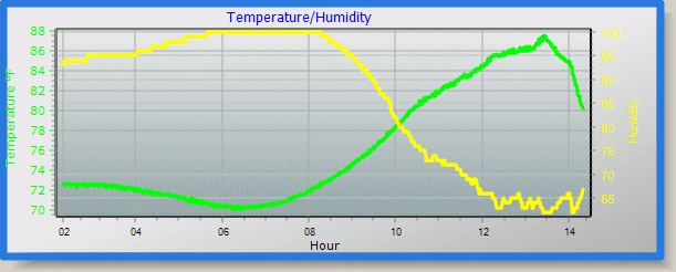
Current Temperature | 80.3°F (26.8°C) (Heat Index 83.0°F ), Apparent temp 85.9°F |
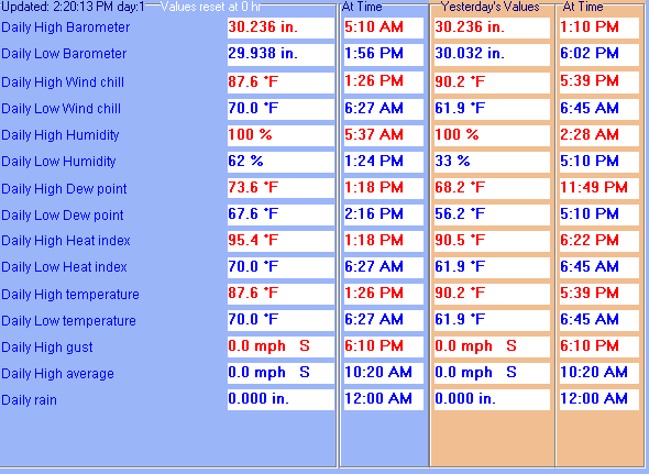
| Maximum Temperature (since midnight) | 87.6°F at: 1:26 PM |
Minimum Temperature (since midnight) | 70.0°F at: 6:27 AM |
| Average windspeed (ten minute) | 0.0 mph |
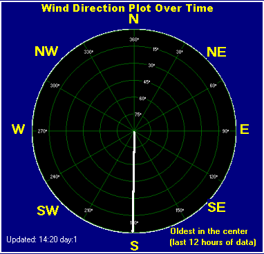
Wind Direction (ten minute) | S (180°) |
| Heat Index | 83.0°F |
Maximum Gust (last hour) | 0.0 mph at: 2:00 PM |
| Maximum Gust (since midnight) | 0.0 mph at: 6:10 PM |
Maximum 1 minute average (since midnight) | 0.0 mph at: 10:20 AM |
| Rainfall (last hour) | 0.000 in. (0.0 mm) |
Rainfall (since midnight) | 0.000 in. (0.0 mm) --- |
| Rainfall This month | 0.00 in. (0.0 mm) |
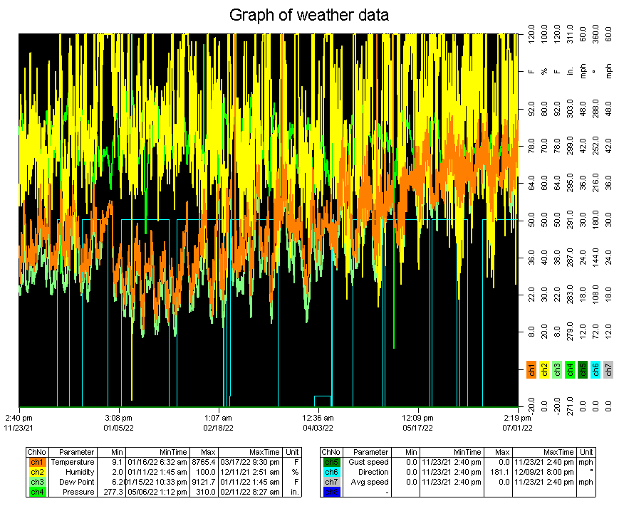
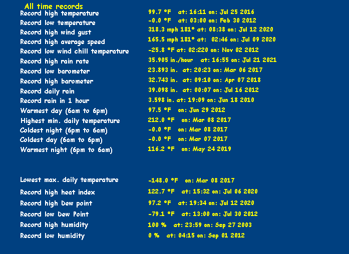
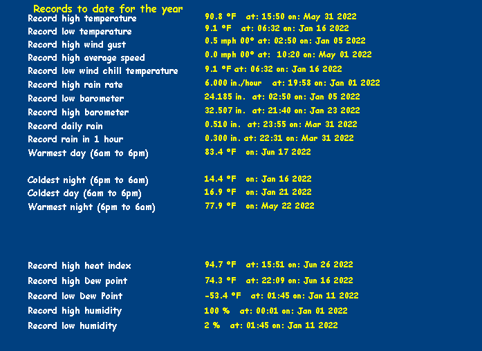
Rainfall To date this year | 2.130 in. (54.1 mm) |
| Maximum rain per minute (last hour) | 0.000 in/min |
Maximum rain per hour (last 6 hours) | 0.000 in/hour |
| Yesterdays rainfall | 0.000 in |
DewPoint | 68.3°F (Wet Bulb :72.4°F ) |
| Humidity | 67 %, Humidex 94.2°F |
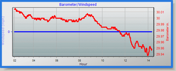
Barometer corrected to msl | 29.946 in. (1014.1 hPa) |
| Pressure change | -0.00 in. (last hour) |
Trend (last hour) | STEADY |
| Pressure change (last 12 hours) | -0.07 in |
Pressure change (last 6 hours) | -0.05 in |

Weather report/warning/Metars
Expires:202207012100;;504340
FPUS51 KLWX 011739
ZFPLWX
Zone Forecast Product
National Weather Service Baltimore MD/Washington DC
138 PM EDT Fri Jul 1 2022
MDZ004-012100-
Frederick MD-
Including the cities of Frederick and Ballenger Creek
139 PM EDT Fri Jul 1 2022
.THIS AFTERNOON...Numerous showers and thunderstorms. Some
thunderstorms may produce small hail and heavy rainfall. Highs in
the lower 90s. Southwest winds 5 to 10 mph with gusts up to
20 mph. Chance of rain 70 percent.
.TONIGHT...Mostly cloudy. Numerous showers and scattered
thunderstorms in the evening, then a chance of showers and
thunderstorms after midnight. Lows in the lower 70s. Southwest
winds 5 to 10 mph. Chance of rain 60 percent.
.SATURDAY...Partly sunny. A chance of showers in the morning,
then showers with thunderstorms likely in the afternoon. Highs in
the upper 80s. Southwest winds around 5 mph. Chance of rain
80 percent.
.SATURDAY NIGHT...Mostly cloudy. Showers with thunderstorms
likely in the evening, then a chance of showers after midnight.
Lows in the upper 60s. Southwest winds around 5 mph, becoming
northwest after midnight. Chance of rain 80 percent.
.SUNDAY...Mostly sunny. Highs in the mid 80s. North winds around
5 mph.
.SUNDAY NIGHT...Mostly clear. Lows in the mid 60s.
.INDEPENDENCE DAY...Sunny. Highs in the upper 80s.
.MONDAY NIGHT...Partly cloudy. Lows in the upper 60s.
.TUESDAY...Partly sunny with a chance of showers and
thunderstorms. Highs in the upper 80s. Chance of rain 50 percent.
.TUESDAY NIGHT...Mostly cloudy with a chance of showers and
thunderstorms. Lows in the upper 60s. Chance of rain 50 percent.
.WEDNESDAY...Partly sunny with a chance of showers and
thunderstorms. Highs in the mid 80s. Chance of rain 50 percent.
.WEDNESDAY NIGHT...Mostly cloudy with a chance of showers. Lows
in the upper 60s. Chance of rain 50 percent.
.THURSDAY...Partly sunny with a chance of showers and
thunderstorms. Highs in the lower 80s. Chance of rain 50 percent.
$$
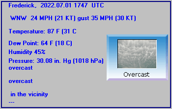
Frederick, Frederick Municipal Airport, MD, United States (KFDK) 39-25-03N 077-22-28W
Jul 01, 2022 - 01:47 PM EDT / 2022.07.01 1747 UTC
Wind: from the WNW (300 degrees) at 24 MPH (21 KT) gusting to 35 MPH (30 KT):0
Visibility: 7 mile(s):0
Sky conditions: overcast
Temperature: 87 F (31 C)
Dew Point: 64 F (18 C)
Relative Humidity: 45%
Pressure (altimeter): 30.08 in. Hg (1018 hPa)
ob: KFDK 011747Z 30021G30KT 7SM BKN043 BKN060 OVC100 31/18 A3008
cycle: 18
The data is logged at two minute intervals, but there is data recorded every minute.
The Web Site is updated at ten minute intervals.
Best viewed in 800 x 600 and True colour.
Use the RELOAD facility
on your browser to retrieve the latest data.
Click here for a daily update of the averages/extremes to date for the month
Created by "Weather Display" software version 10.37S at this start time/date 2:30:40 PM 11/23/2021